
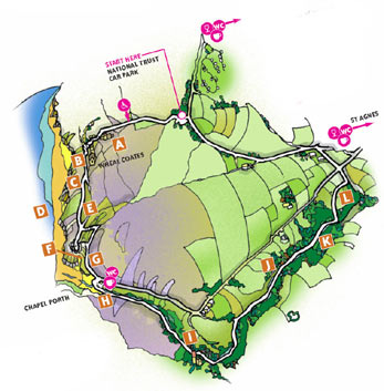
- The Walks
 Walk 1 - St.Agnes Village Trail
 Walk 2 - St Agnes Beacon
 Walk 3 - Porthtowan, Banns Vale, Mount Hawke and Chapel Porth
 Walk 4 - Wheal Rose, The Poldice Plateway and Mawla
 Walk 5 - Mount Hawke
 Walk 6 - Mithian
 Walk 7 - Wheal Coates, Chapel Porth, Wheal Lawrence Valley and Goonvrea
 Walk 8 - Water Lane, Wheal Butson and Jericho Valley
 Walk 9 - Jericho Valley and Cross Coombe
 Walk 10 - Blackwater
Walk 7 - Wheal Coates, Chapel Porth, Wheal Lawrence Valley and Goonvrea
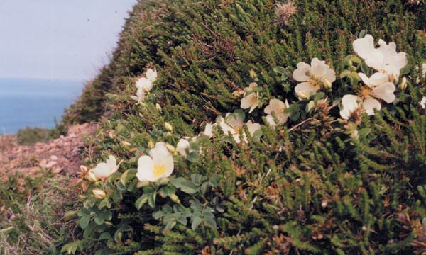 Where the path forks take the lower
path. Head towards the rocky outcrop
(known as White Rocks) above the cove
at Chapel Porth; by the path in the spring
you may be lucky enough to see the lowgrowing
burnet rose E, its white petals
bright against apple green leaves.
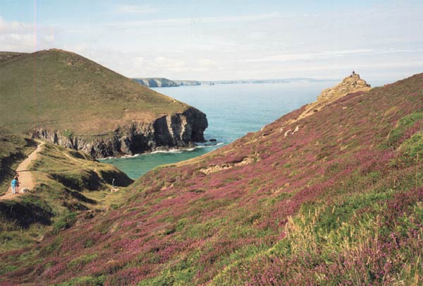
White Rocks is a great vantage point for
viewing Chapel Porth, and the rock itself
is covered by beautiful mustard coloured
and blue-grey lichens. Early flowering
scurvy grass, followed by sea campion
and thrift, take advantage of the cracks
and hollows in and around the rock.
Where the path forks take the lower
path. Head towards the rocky outcrop
(known as White Rocks) above the cove
at Chapel Porth; by the path in the spring
you may be lucky enough to see the lowgrowing
burnet rose E, its white petals
bright against apple green leaves.
White Rocks is a great vantage point for
viewing Chapel Porth, and the rock itself
is covered by beautiful mustard coloured
and blue-grey lichens. Early flowering
scurvy grass, followed by sea campion
and thrift, take advantage of the cracks
and hollows in and around the rock.
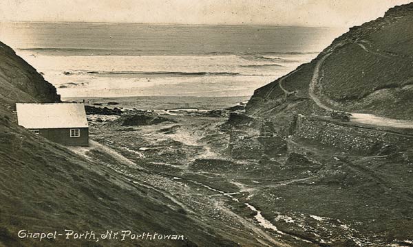
White Rocks to Chapel Porth
Retrace your steps for a few yards and follow the path which winds towards the beach. A bench sits by
the bend in the path. If you fancy a brief detour to see the rather 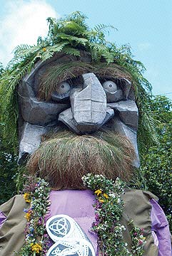 small imprint of Giant Bolster's foot, take the
path immediately behind the bench. About a hundred metres up the path is the
moorstone topped by its 'footprint'. Return to the bench and continue towards the
cove. On your right is a grassy area, the tussocks and thrift covering old walls where
St Agnes Chapel stood. The Eighteenth century historian Dr William Borlase mentions
the chapel and describes the building over St Agnes Well in some detail. The well,
which
small imprint of Giant Bolster's foot, take the
path immediately behind the bench. About a hundred metres up the path is the
moorstone topped by its 'footprint'. Return to the bench and continue towards the
cove. On your right is a grassy area, the tussocks and thrift covering old walls where
St Agnes Chapel stood. The Eighteenth century historian Dr William Borlase mentions
the chapel and describes the building over St Agnes Well in some detail. The well,
which 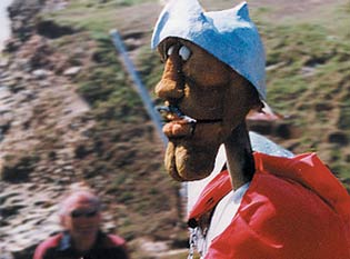 disappeared in the nineteenth century, was on the edge of the cliff, probably above the double cave known as Two Vugs. Here in the spring the cliffs are covered with blue squill, yellow
kidney vetch and pink thrift and here in May the story of Giant Bolster and St Agnes is re-enacted by the local
community F. In the same grassy area in July, glow worms light up at dusk. Another bench provides a point
from which, when the tide is out, the boiler from the SS
disappeared in the nineteenth century, was on the edge of the cliff, probably above the double cave known as Two Vugs. Here in the spring the cliffs are covered with blue squill, yellow
kidney vetch and pink thrift and here in May the story of Giant Bolster and St Agnes is re-enacted by the local
community F. In the same grassy area in July, glow worms light up at dusk. Another bench provides a point
from which, when the tide is out, the boiler from the SS 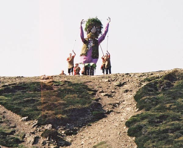 Eltham, wrecked in 1928, can be seen to the left of the
beach. Around the edges of the cliffs, samphire, a food plant in earlier centuries, appears as patches of bright
green. Follow the path to the road and the car park G.
Eltham, wrecked in 1928, can be seen to the left of the
beach. Around the edges of the cliffs, samphire, a food plant in earlier centuries, appears as patches of bright
green. Follow the path to the road and the car park G.
The Car Park
 In the nineteenth century the car park area contained a stamping mill driven by a twenty foot diameter water
wheel, positioned by the wall next to the present day toilets. Stamps crushed the rock containing tin ore and
buddles then separated the heavy tin from the waste rock.
In the nineteenth century the car park area contained a stamping mill driven by a twenty foot diameter water
wheel, positioned by the wall next to the present day toilets. Stamps crushed the rock containing tin ore and
buddles then separated the heavy tin from the waste rock.
Wheal Lawrence Valley
 Cross the bridge by the café and follow the path by the side of the stream. In spring, the stream is
fringed by hemlock water dropwort, and in summer by soft pink hemp agrimony and yellow fleabane H. A
hundred metres from the car park two banks of earth form a partial barrier across the valley. During and just
after the Second World War, a wooden bridge connected these two banks, built, together with the wide track
leading up the hillside, as a training exercise by US troops stationed at the camp near St Agnes Head. Next to
the bank is a wet area with a very obviously circular dome of raised bog which reflects the shape of a buddle
underneath. Here in summer royal ferns tower over other vegetation and the 'chink chink' of stonechats is
likely to be heard as they flit from bramble to bush.
Cross the bridge by the café and follow the path by the side of the stream. In spring, the stream is
fringed by hemlock water dropwort, and in summer by soft pink hemp agrimony and yellow fleabane H. A
hundred metres from the car park two banks of earth form a partial barrier across the valley. During and just
after the Second World War, a wooden bridge connected these two banks, built, together with the wide track
leading up the hillside, as a training exercise by US troops stationed at the camp near St Agnes Head. Next to
the bank is a wet area with a very obviously circular dome of raised bog which reflects the shape of a buddle
underneath. Here in summer royal ferns tower over other vegetation and the 'chink chink' of stonechats is
likely to be heard as they flit from bramble to bush.
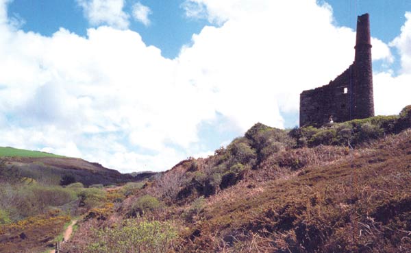 As the path rounds the hillside, Charlotte United engine house comes into view I, part of a complex of mines
which is recorded as having produced 23,000 tons of 8.5 percent copper ore. A little bridge below the engine
house spans the iron-stained water which flows from an adit or tunnel built to release water from the mine.
As the path rounds the hillside, Charlotte United engine house comes into view I, part of a complex of mines
which is recorded as having produced 23,000 tons of 8.5 percent copper ore. A little bridge below the engine
house spans the iron-stained water which flows from an adit or tunnel built to release water from the mine.
 Contact Us
Site Map
Concept by Graeme and Rust
Build by uknetweb